
Telaga Dua
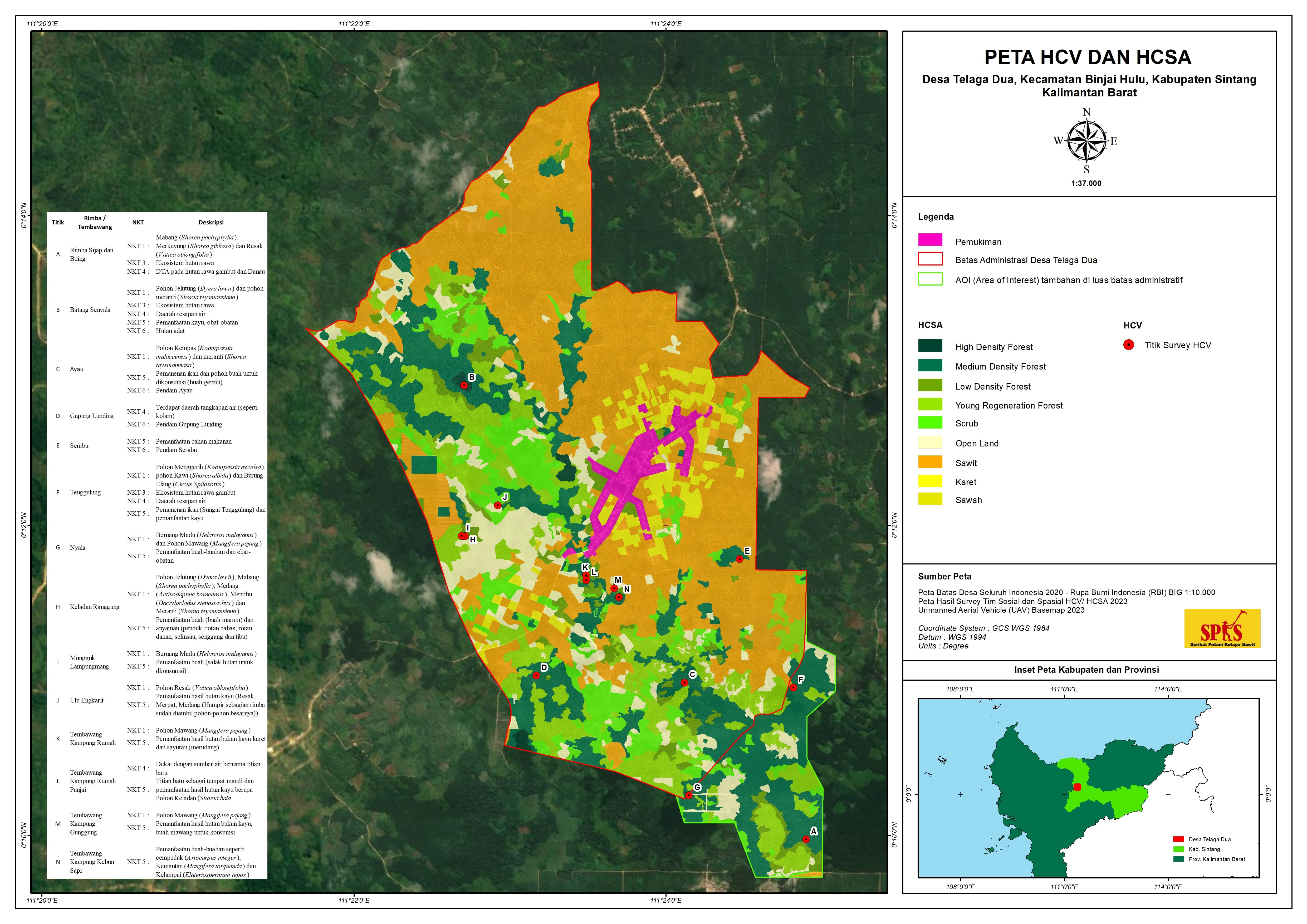
Telaga Dua Village is administratively located in Binjai Hulu Subdistrict, Sintang Regency, West Kalimantan Province, covering an indicative area of 21.00 km² (2,100 hectares). It borders Sungai Risap Village (Binjai Hulu) to the north, Binjai Hilir Village (Binjai Subdistrict) to the east, Telaga Satu Village (Binjai Hulu) to the south, and Ensabang Village (Sepauk Subdistrict) to the west.
908
Total Farmers
0
Farmer Groups
40
Protected Forest (Ha)
0
Village Documents
Location Map
Lat: 0.2064650 | Lng: 111.3970400
Village Narrative & Story
Geographical Condition & Profile
Telaga Dua Village is administratively located in Binjai Hulu Subdistrict, Sintang Regency, West Kalimantan Province, covering an indicative area of 21.00 km² (2,100 hectares). It borders Sungai Risap Village (Binjai Hulu) to the north, Binjai Hilir Village (Binjai Subdistrict) to the east, Telaga Satu Village (Binjai Hulu) to the south, and Ensabang Village (Sepauk Subdistrict) to the west.
The village has a population of 1,413 people (703 males and 711 females) across 417 households. Telaga Dua is divided into four hamlets: Suka Maju, Tegal Sari, Karang Indah, and Buinasi. The majority of residents work as farmers or smallholder cultivators.
Historically, Telaga Dua originated from a settlement known as Kampung Batangtuk or Kampung Telaga, which later developed into Telaga Village and eventually split into Telaga Dua and Telaga Satu. The early settlement was led by a Head of Kampung assisted by a Kebayan. Among the former leaders were Mr. Encanga and Mr. Lubit, the latter having led both Telaga Satu and Telaga Dua. Later leaders of Telaga Dua included Mr. Ingkan and Mr. Samsudin.
In 1982, Telaga Dua became a site for both local and general transmigration programs, administratively managed by a Head of the Transmigration Management Unit (UPT) until 1991. Historically, the area was inhabited by the Seberuang sub-tribe. Oral history recounts that the Ketungau Sebaruk sub-tribe assisted the Seberuang in a tribal conflict (ngayau). Following their victory, the Ketungau Sebaruk received shared rights over resources such as honey, tembawang (traditional fruit groves), and other assets, as previously promised. Initially intending to travel to Pontianak, they settled in the area they believed to be their destination and remained there due to this alliance.
Indigenous People & Local Wisdom
-
Commodity Distribution
Farmer Groups
No farmer group data yet.
Land Use & Forest Data
Latest data year: 2023
| Year | Forest/Land Name | Indicative (Ha) | Definitive (Ha) | Type | Status | HCS-HCV |
|---|---|---|---|---|---|---|
| 2023 | - | 40.00 | 40.00 | - | Area Penggunaan Lain (APL) | - |
Visual Gallery
Reference Documents
No documents yet.