
Santaban
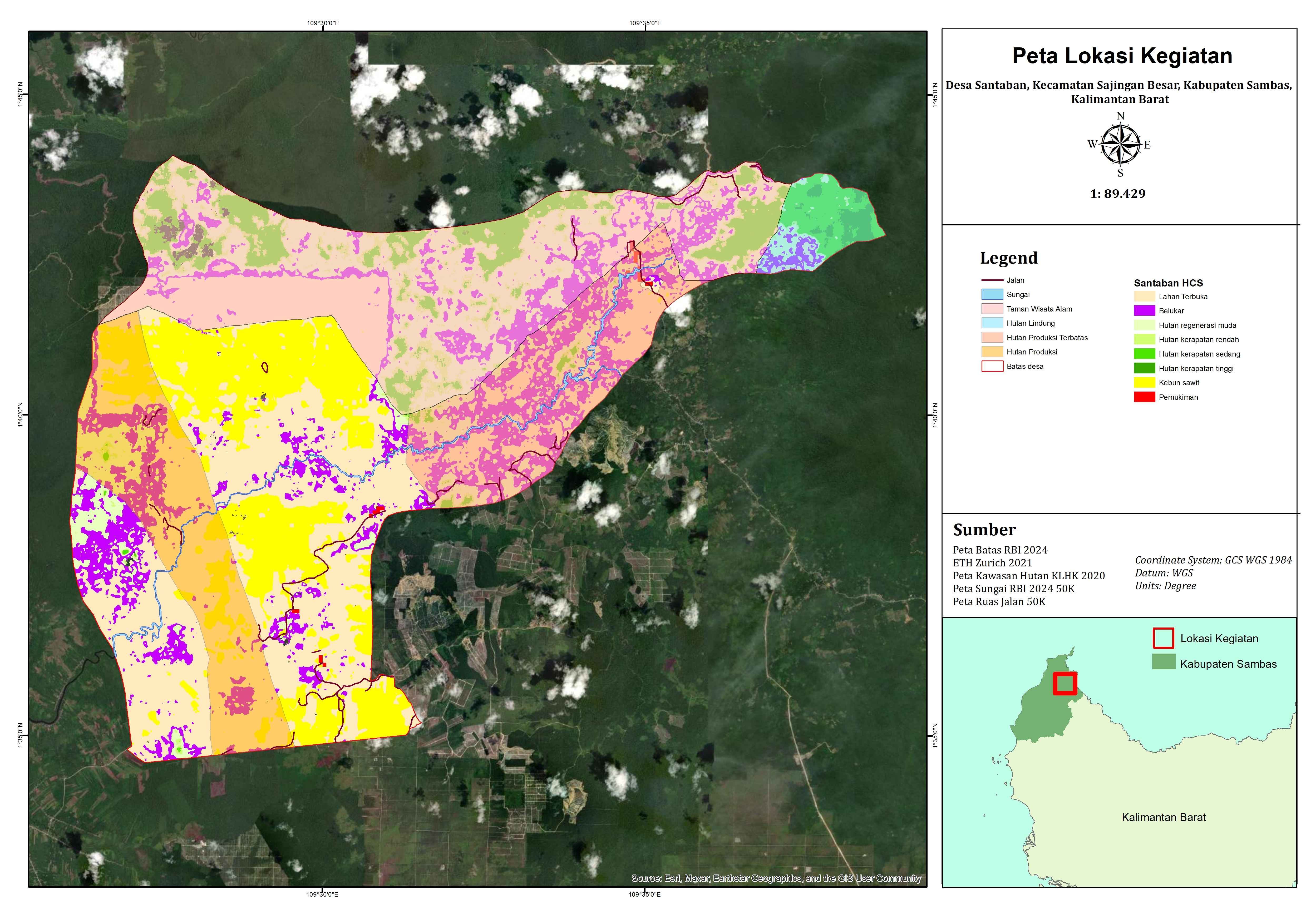
Santaban Village is located in Sajingan Besar Subdistrict, Sambas Regency, West Kalimantan Province, with an area of 180 km² (18,000 ha). To the north, Santaban Village shares a border with Sungai Bening Village (Sajingan Besar Subdistrict); to the east, it shares a border with Sanatab Village (Sajingan Besar Subdistrict); to the south, it shares a border with Semangak Village (Sijangkung Subdistrict); and to the west, it shares a border with Sagu Village (Galing Subdistrict). Santaban is divided into three sub-villages, namely Sasak, Senipahan, and Batang Air.
0
Total Farmers
0
Farmer Groups
-
Protected Forest (Ha)
0
Village Documents
Location Map
Lat: 1.5806130 | Lng: 109.5044200
Village Narrative & Story
Geographical Condition & Profile
Santaban Village is located in Sajingan Besar Subdistrict, Sambas Regency, West Kalimantan Province, with an area of 180 km² (18,000 ha). To the north, Santaban Village shares a border with Sungai Bening Village (Sajingan Besar Subdistrict); to the east, it shares a border with Sanatab Village (Sajingan Besar Subdistrict); to the south, it shares a border with Semangak Village (Sijangkung Subdistrict); and to the west, it shares a border with Sagu Village (Galing Subdistrict). The village has a population of 2,405 people with 635 households. Santaban is divided into three sub-villages, namely Sasak, Senipahan, and Batang Air. The majority of the population of Santaban Village are farmers/planters, numbering 400 people.
There are no official historical records regarding the origins of the Santaban ancestors and when they began inhabiting the five old villages (Angus, Riam, Kaum, Tuba, and Batang Air) of the Santaban community, which has now become a village. However, based on oral traditions passed down from generation to generation, when the traditional customs and systems were introduced to Santaban by a man named Nek Undah and his seven friends in the 1500s (the names of the seven friends are forbidden to be mentioned arbitrarily according to custom), the five old villages of Santaban already existed and had residents living in betang houses, although the number was not large.
Nek Undah and her seven friends came from Garantugk, in the Singkawang region. They were looking for a new place to live with soil similar to that in Singkawang. In order to find soil with similar characteristics, they brought soil from Singkawang with them, which they stored in a gong, as well as a weighing device called a “gora” or “dacing caragu”. In every area they visited, they always took soil from that area in the same amount as the gong they carried and weighed it. They compared the weight of the soil with the soil they brought from Singkawang. If the weight was the same, they would stay, but if the weight was different, they would stay temporarily before leaving again to look for a new place.
Before arriving in the Santaban area, they passed through many areas such as Bengkayang, Sanggau, and even Malaysia. In these places, they always weighed the soil to find a match with the soil they had brought with them from Singkawang. However, none of these places had soil that matched the weight of the soil they had brought with them. Only in Santaban did they find the soil they were looking for, so they decided to settle there. They then mingled with the local community and built a civilisation based on the cultural system/practices (customs) they brought with them from Singkawang. These eight individuals became the first traditional elders of the Dayak Salako (a sub-tribe of the Dayak Kanayatn/Klemantan) in Santaban, who had the authority to regulate all aspects of community life, with Nek Undah as the supreme leader. Their descendants are the traditional leaders in the kampongs of Santaban to this day.
Later on, several people from the villages of Riam and Kaum began opening up land to the south. They would sometimes stay in their fields during certain seasons, as they were quite far from their kampongs. Due to this situation, in the 1950s, they decided to establish a residence in the farmland area. This residence became the forerunner of the current sub-village of Sasak.
Then, in 1982, the government suggested local transmigration for all residents of the five old kampongs to the area that is now Senipahan Sub-village. This relocation was based on considerations regarding the distance children had to travel to school and other places such as markets and health facilities. After moving to Senipahan, the community continued to farm in their old kampongs, which was quite far away. This caused the residents from Batang Air kampong to decide to return to their old kampong and then open a new kampong to the north of the old kampong, which they continued to call Batang Air (now Batang Air Sub-village).
Administratively, Santaban Village was formed in 1986. Before that, the Santaban area was part of Sagu Village, Teluk Keramat Subdistrict. The formation of Santaban Village was a follow-up to the expansion of two new subdistricts from Teluk Keramat Subdistrict, namely Galing Subdistrict and Sajingan Besar Subdistrict. Santaban Village then became part of Sajingan Besar Subdistrict, while Sagu Village became part of Galing Subdistrict.
Indigenous People & Local Wisdom
Village Forest Management Institution
Commodity Distribution
No commodity data.
Farmer Groups
No farmer group data yet.
Land Use & Forest Data
No forest data yet.
Visual Gallery
Reference Documents
No documents yet.