
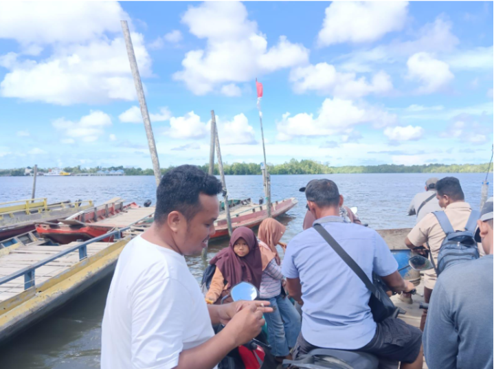
The sky was fairly clear. Several motorcycles were pushed along a small road and loaded onto a boat. Among the motorcycle owners crossing the river were parents who had just picked up their children from school.
‘If we want to go to the other side, we have to take a boat. For cars, you have to take the ferry,’ said Adi, one of the local facilitators, pointing to the ferry docked on the other side of the Paloh River, waiting to transport cars across.
That day was the third day of Team 4F's social mapping. The purpose of social mapping is to describe a community based on data and information about its profile and social issues in the surrounding area. The focus of the social mapping that day was to gather information from farmers in the sub-village of Cermai regarding issues related to mangrove forest management in the hamlet. This sub-village (along with the sub-village of Sungai Tengah) can only be reached from nine other sub-villages by crossing the Paloh River. The crossing is about 500 metres long and takes about 10-15 minutes. Motorcycles are transported using boats that cross once they are fully loaded, while cars are transported using a ferry that departs once an hour. It costs £6 per motorcycle to cross, while cars transported using the ferry are charged £18 per unit.
Figure 1. Paloh river crossing point. A ferry boat is seen on the other side of the river, ready to transport cars across.
Source: 4F Documentation.
There are no bridges, only boats and ferries. This is not due to government indifference or a lack of state funds. Previously, the government had a plan to build a bridge, and abutments (footings) had even been constructed on both sides of the river. However, due to the depth and width of the Paloh River and its powerful currents, the bridge construction plan was not continued. According to local residents, at the crossing point alone, the Paloh River is more than 500 metres wide, as indicated by the length of the electricity cables installed by state-owned electricity company (PLN) to supply electricity to the sub-villages of Cermai and Sungai Tengah, as far as Temajuk Village (a northern village that was formerly part of Sebubus).
This crossing point on the Paloh River is always busy every day, from morning to night. This place is vital for the activities of the communities of Cermai and Sungai Tengah sub-villages, as well as Temajuk village. Through this crossing point, they are connected to nine other hamlets in Sebubus, to the village centre, to the sub-district capital of Paloh (in Nibung village), and even to the capital of Sambas district, which takes about 2 hours by motorbike or car. At this location, not only people are ferried across, but also agricultural and marine products from the sub-villages of Cermai and Sungai Tengah, such as palm oil, fruits (pineapples, mangoes, rambutans, durians, watermelons), vegetables (mustard greens, chillies, tomatoes), fish, crabs, prawns, and salt.
Stages and Processes of Social Mapping
The social mapping activity conducted by 4F in Sebubus Village (Paloh Subdistrict, Sambas District, West Kalimantan Province) took place from 12 to 18 November 2025. This activity is part of the initial assessment of a series of “Increasing Community Income Program through Forest Protection and Agroforestry Implementation”. This activity is a collaborative programme or partnership between Solidaridad, the Palm Oil Farmers Union (SPKS), and 4F.
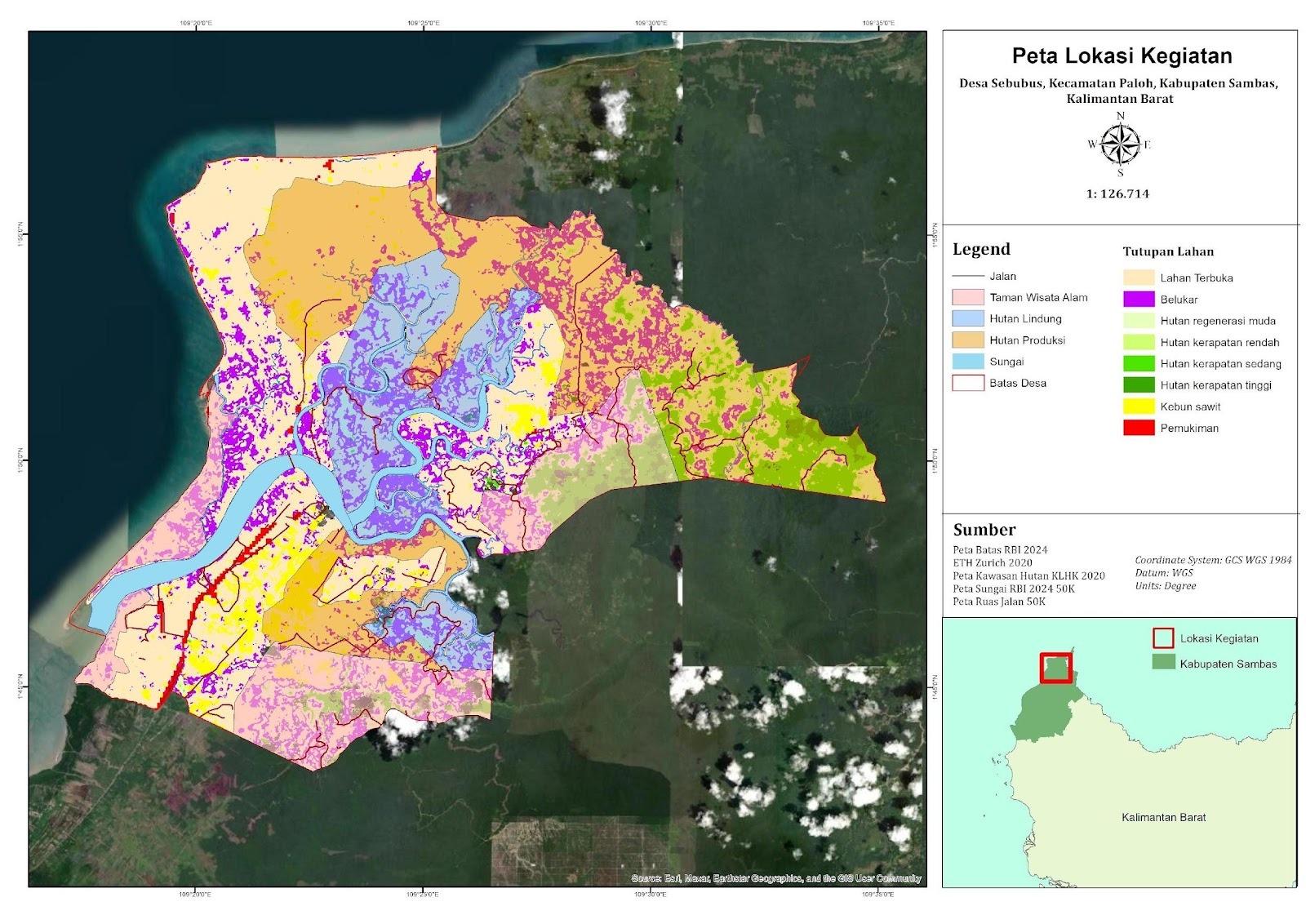
Figure 2. Map of the village of Sebubus.
Source: 4F documentation.
The implementation of this social mapping began with a socialisation (meeting 1) on 11 November 2025 in the Sebubus village office hall. This socialisation was the second stage of the HCS-HCV Smallholders Toolkit methodology and played an important role in obtaining approval from all farmers and community representatives to implement this toolkit. Through this first socialisation, 4F hoped to receive inputs from the villagers (represented by the meeting participants) in the form of constructive ideas, concerns, and objections to certain activities. All inputs from the participants became the basis for 4F's consideration or decision to continue with the preparation of the toolkit implementation plan. This activity was attended by 33 participants consisting of representatives from the Sebubus Village Administration, community leaders, farmers, and women's representatives.
During this meeting, the Head of Sebubus Village gave a brief introduction about Sebubus Village and the situation regarding natural resource management (especially mangrove forests) in their village. “We, the Sebubus Village Administration, support forest protection activities in our village. In 2018, together with the PKH (Forest Area Control) Task Force, a survey was conducted in Sebubus Village. The process has resulted in a draft village regulation on the protection of 1,300 hectares of APL forest, especially in the mangrove forest areas. Our draft of village regulation has been submitted to the Sambas Regional Government and is awaiting revision.” In addition, he added his hopes for the activities to be carried out by 4F in Sebubus: “The village regulation that we have drafted is also the result of a mutual agreement, but there are still people who are clearing the APL mangrove forest. We have also formed a Forest Guard Team through a decree. My concern is that there are no clear sanctions that can be applied to the community. Perhaps the experiences of 4F in the customary forests of Sanggau, Sekadau and Sintang districts can be applied in our draft village regulation.”
Figure 3. The village head of Sebubus (right) giving a speech accompanied by Yowan, a representative of 4F.
Source: 4F documentation.
Team 4F also gave a general explanation of the background and series of activities that 4F would carry out in Sebubus village, consisting of meeting 1 (socialisation and awareness raising), social mapping, meeting 2 (mapping of important areas in the Sebubus village community), field verification (review and observation of important areas), and finally, an integrated land conservation and utilisation plan accompanied by management and monitoring.
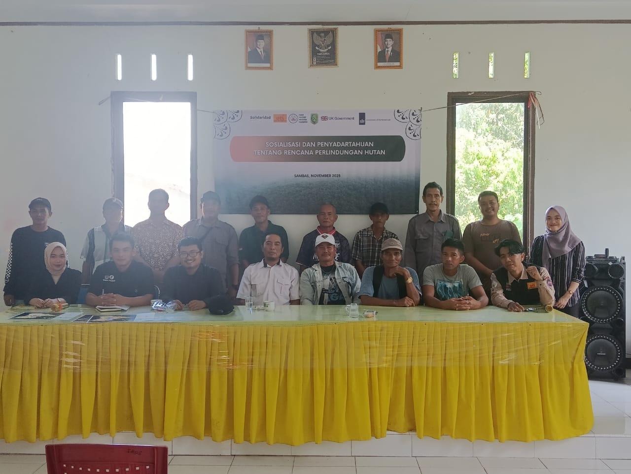
Figure 4. Some participants attended the initial socialisation session.
Source: 4F documentation.
Following the socialisation, the social mapping process commenced. Team 4F, together with the social mapping expert team, accompanied by two local facilitators (Tanamal and Aditya), conducted interviews with several figures who had knowledge about Sebubus village, such as the history of the village, population, social dynamics of the community, history of land clearing, natural resources of the village, and other social aspects. This social mapping was carried out over six days, from 12 to 15 November, and then continued on 17 and 18 November (16 November was a Sunday and several informants were unable to be interviewed on that day). A total of 18 informants were interviewed, consisting of representatives of the village administration, head of sub-villages, former village heads, members of the mangrove lovers group, salt farmers, palm oil farmers, and two female figures (a rattan weaver and a maker of sweets/drinks from mangrove fruits).
Discovering a glimpse of Sebubus Village
Sebubus Village has a population of over 5,000 and consists of 11 sub-villages (Sebuluh, Serumpun, Melati, Setingga Asin, Setingga Tawar, Jeruju, Jeruju Utara, Merbau, Sungai Dungun, Cermai, and Sungai Tengah). This initial data was verified during social mapping. The area covers 32,621 hectares, divided into 11 hamlets, 22 Community Groups (RW) and 48 Neighbourhood Groups (RT). The population is 10,958 (5,500 men/5,458 women) and 2,906 households (data from October 2025). The majority of the population is of Sambas Malay ethnicity and Muslim (7,925 people), so it is not surprising to see mosques and small mosques (surau/mushola) when walking along the streets of Sebubus village.
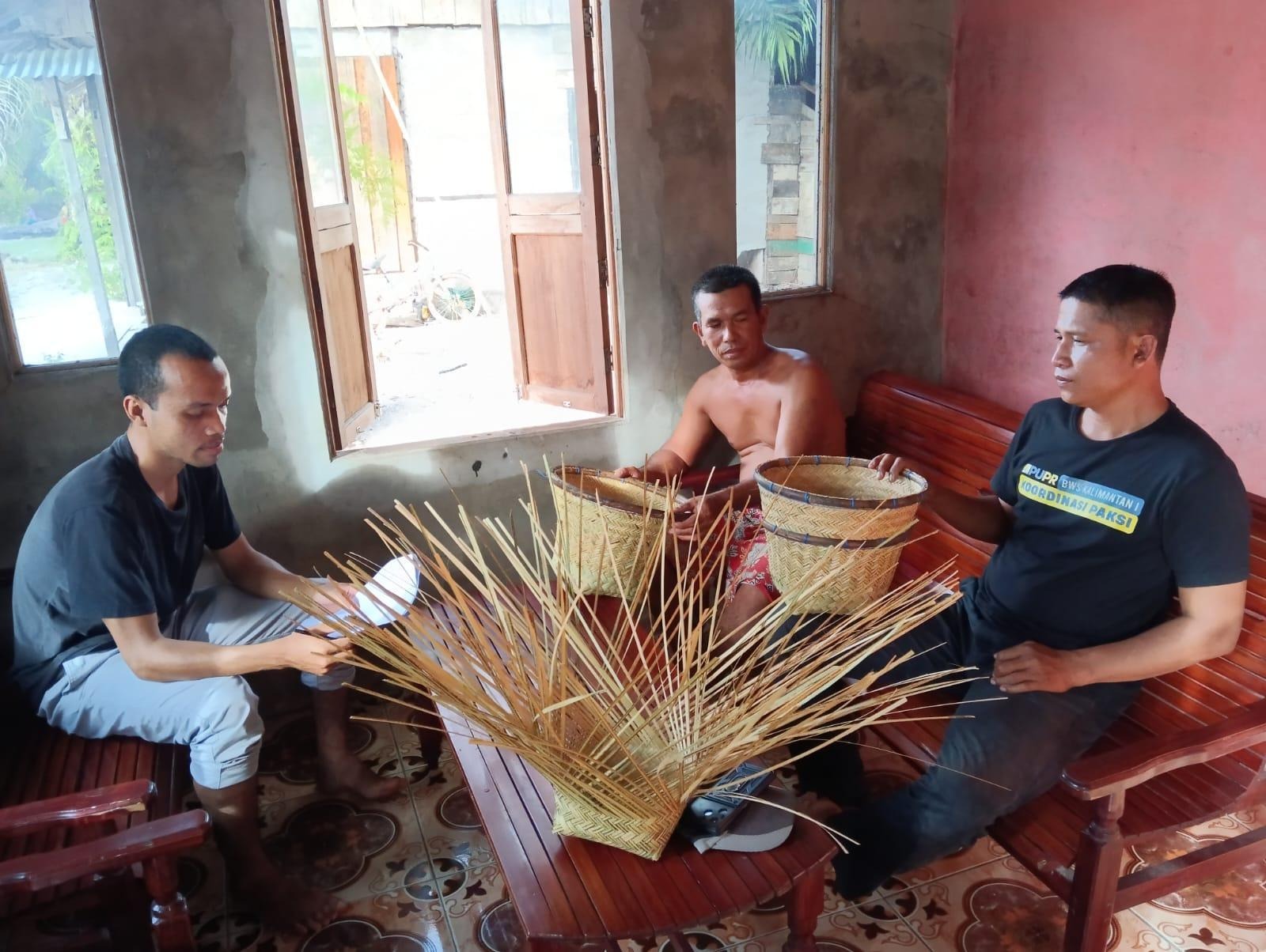
Figure 5. Interview with Mr Kardianto (centre), a palm oil farmer who always helps his wife with her work as a rattan weaver.
Source: 4F documentation.
Sebubus Village is a lowland area with many rivers. None of the informants interviewed knew the exact number and names of all the rivers in Sebubus. This is not only because there are so many rivers, but also because the community cannot remember the names and numbers of tributaries, as one river can have more than two tributaries. Because it is located in a lowland area, all the rivers in Sebubus are brackish (a mixture of fresh water and salt water) and the water levels follow the rhythm of the sea (increasing during high tide and decreasing during low tide). This condition means that the river water in Sebubus village cannot be used to irrigate the community's rice fields. The community's rice fields solely rely on rainwater and are highly dependent on natural conditions. However, despite the river water being unsuitable for agricultural commodities, the villagers still derive benefits from their rivers, such as easier access to their gardens (the rivers are used as transportation routes using boats) and the abundance of fish, shrimps, lobsters and crabs.
Besides being well-known for its rivers, Sebubus village also has many forest areas, especially mangrove forests. Out of 13 forest areas recorded during social mapping, there are 7 mangrove forests. Among these 7 mangrove forests, 2 are designated as nature parks managed by the Paloh Sub-district Natural Resources Conservation Agency (BKSDA), while the other 5 are classified as other land use, namely the Mutusan 1 River Mangrove Forest (500 hectares), the Mutusan 2 River Mangrove Forest (200 hectares), the Merbau Mangrove Forest (100 hectares), the Setingga Hamlet Mangrove Forest (35 hectares), and the Tanjung Kluang Mangrove Forest (216 hectares). Mangrove forests play an important role to the Sebubus villagers, such as preventing abrasion, providing firewood and scaffolding wood, providing fruit for syrup and sweets (pidada tree), a nesting place for stingless bees that produce honey, and a place to catch fish, shrimps, lobsters, crabs and snails (there are rivers in the mangrove forests where fishermen catch seafood).
Testimonials and Hopes
During the social mapping process, several informants asked about the purpose, objectives and follow-up of the activities carried out by 4F in Sebubus village. They wanted to know what 4F wanted from the data gathered and the benefits that 4F would provide to the Sebubus villagers. After explaining that the activities in Sebubus were part of a series of programs to empower farmers through agroforestry training and forest protection, including the possibility of creating a village regulation on the protection of natural resources in Sebubus, several of them responded positively. One of them was Mr Hernan Djanamis, a former agricultural extension worker. Holding a 4F brochure that coincidentally was brought along by a local assistant, he commented on the activities carried out by 4F, “From what I see in this pamphlet, this is a very good programme. Especially if there is a village regulation to protect the forests in the village. That will really help us in this village to protect the forest from being destroyed.”
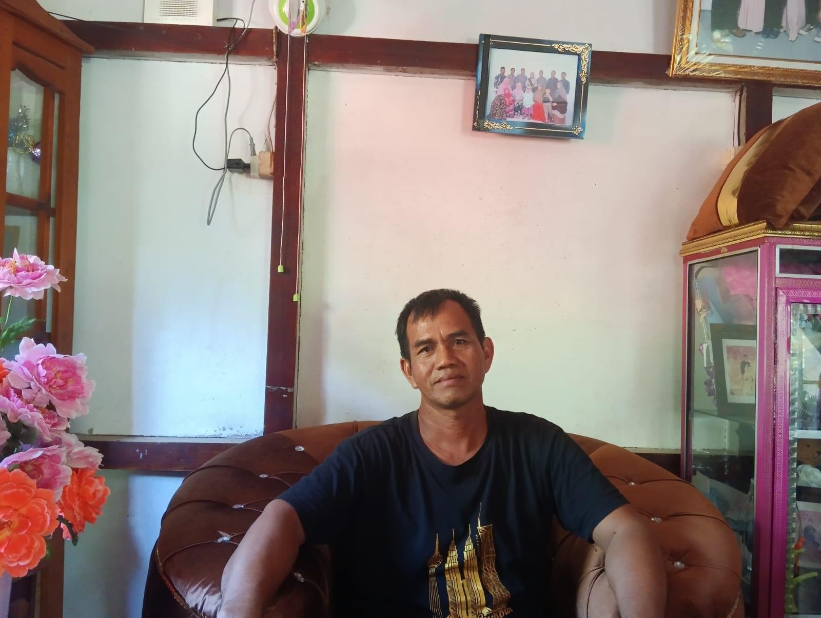
Figure 6. Mr Ramli, Head of Setingga Asin Hamlet and Chair of the Sebubus Village Forest Management Institution.
Source: 4F documentation.
As well as Mr Hernan, another person who gave a positive impression was Mr Ramli (Head of Setingga Asin Hamlet and Chair of the Sebubus LPHD). "Personally, I am very happy and proud when outsiders come into our forests and mention the scientific names of the animals or plants they find. I am touched because it turns out that the forests in our village are very rich,” he said when he learned that one of the follow-ups to this social mapping was forest protection. He also hopes that this activity can be the first step in making the mangrove forests in Sebubus and their riches widely known. “Hopefully, the information you have obtained can help. And for us, what we have, whether it be mangrove forests, primates, or biodiversity, can be exposed to the outside world and attract academics, students, and tourists, both domestic and foreign, for research or tourism."