
Farmers for Forest Protection Foundation (4F)
Implementation of the High Carbon Stock-High Conservation Value (HCS-HCV) toolkit carried out by 4F continued in Kenawan Village, Permata Kecubung Sub-district, on 8 April 2026. Three members of 4F's spatial team were guided by two local facilitators towards the forest areas due to be verified. These forests had been jointly identified together with community representatives during Musyawarah 2 (the meeting to determine areas of importance to the community), held the day before (7 April) at the Kenawan Village hall.
At that Musyawarah 2, five forests were identified as important areas to be protected by the community, namely Pebantan Laman Selapat Onam (0.10 ha), Pebantan Sabang Paburuka (0.09 ha), Pebantan Arai Seborang (0.67 ha), Batu Kelelawar Forest (0.66 ha) and Batu Rujung Rayo Forest (5.03 ha). All five of these important-area forests lie within the State Forest Zone (Kawasan Hutan Negara/KHN).
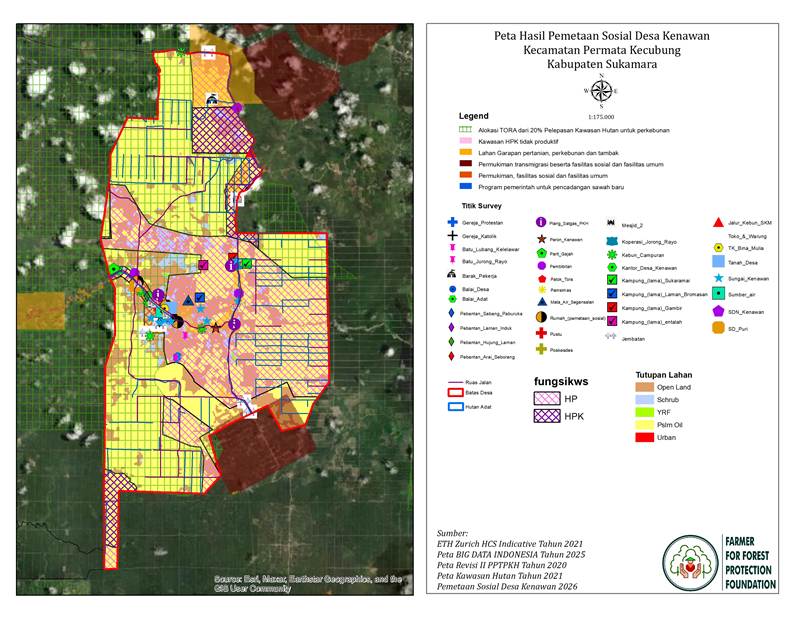
Figure 1. Map of the results of the social mapping of Kenawan Village, Permata Kecubung Sub-district, Sukamara District, Central Kalimantan.
4F's spatial team was guided by the local facilitators towards the first forest. The verification party, made up of five people, stopped at an area situated beside a resident's house and close to the main road.
“This is the forest, sir. It only runs from there to there,” said Mr Molen, one of the local facilitators, pointing towards the spot in question when asked by one of the 4F team members about the location of the forest they were heading to.
That area is what is known as Pebantan Laman Selapat Onam and Pebantan Sabang Paburuka. Both lie within a single, continuous area, with no boundary separating them.
These two pebantan do not look like forest or jungle, but rather like a mixed garden. Both are located close to the main road (around 20 metres away) and lie behind the kitchen of a resident's house in RT 02.
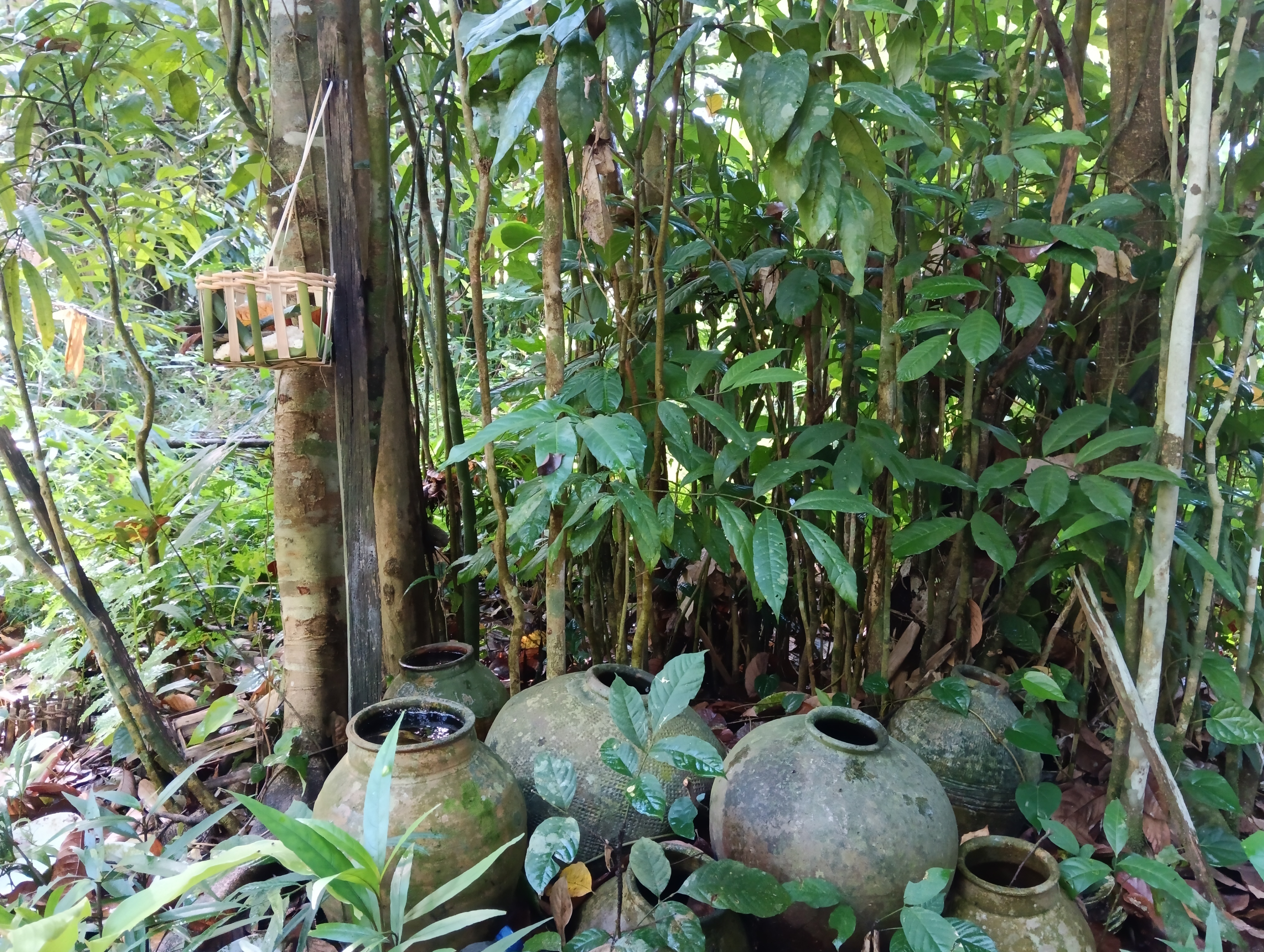
Figure 2. Traditional ritual site of the Kenawan Village community, in part of Pebantan Sabang Paburuka.
There are not many trees within the two pebantan. A few large trees can be found, but almost all of them are fruit trees such as Mentawa (Artocarpus anisophyllus), Durian (Durio zibethinus), Dukuh (Lansium domesticum) and Asam Bacang (Mangifera foetida). Even so, the trees are spaced quite far apart, around 5-10 metres.
Going by area alone, Pebantan Laman Selapat Onam and Sabang Paburuka cannot meet the category or classification of forest. The combined area of the two pebantan is only 0.19 ha, whereas under Minister of Forestry Regulation No. P.14/Menhut-II/2004, an area can only be termed forest if it covers a minimum of 0.25 ha.
Although these two pebantan are more accurately described as mixed gardens than forest, they hold values that are upheld together by the community according to custom and culture, regarded as sacred and closely bound up with the community's continued survival.
“This pebantan is indeed small and doesn't look like a forest, sir, but we protect this place together because these ritual sites lie within it,” Mr Molen continued.
At the ritual site, several earthenware jars are lined up beneath the trees, along with offerings placed inside a woven bamboo-and-wood structure hung from a tree, known locally as an Ancak. According to the local facilitator, it is here that the Kenawan community carries out its traditional rituals, ranging from customary thanksgiving ceremonies to prayers warding off misfortune.
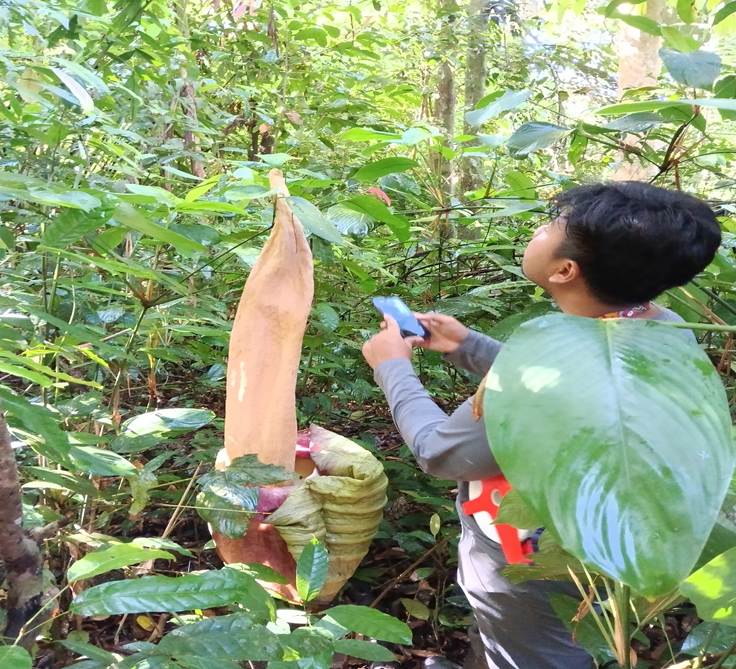
Figure 3. One of the species of corpse flower (Amorphophallus titannum) found at Pebantan Laman Selapat Onam.
Besides the ritual site's deep connection with the Kenawan community, a rare plant was also found within this ritual area, namely a species of corpse flower, Amorphophallus titannum. This flower grows tall and appears undisturbed by the scrub surrounding it.
The Stony Forests
After completing the survey at Pebantan Laman Selapat Onam and Pebantan Sabang Paburuka, the 4F team and local facilitator moved on to an area in RT 03 called Pebantan Arai Seborang. Here, the field verification team did not spend much time (only around 15 minutes), as the area had already been planted with oil palm. Even so, it still contained important features requiring protection, such as a stream and a stand of bamboo.
After verifying Pebantan Arai Seborang, the verification team spent around 20–30 minutes travelling to Hutan Batu Kelelawar. To reach this forest, the 4F team and local facilitator had to leave the main road and pass along a community oil-palm plantation track dominated by red, sandy soil.
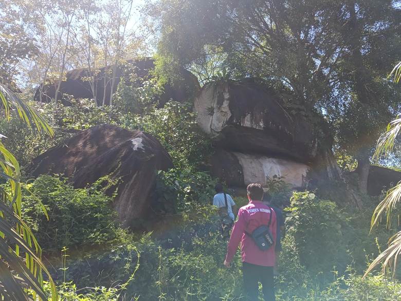
Figure 4. View of Hutan Batu Rujung Rayo from the outside.
Hutan Batu Kelelawar is dominated by large rocks of historical value, regarded as sacred by the community. Despite its small size, the forest still contains large hardwood trees, such as Torap (Artocarpus elasticus), Ubar (Syzygium spp.), Bukir (Dacryodes rostrata), Penaga (Calophyllum spp.) and Pampan (Shorea spp.). Besides these large trees, within this forest 4F's spatial team also found a medicinal plant commonly known to the Kenawan community as the ‘petugas’ plant, used to treat lower back pain.
After spending around two hours surveying Hutan Batu Kelelawar, 4F's spatial team and the local facilitator set off for Hutan Rujung Rayo. The journey to this forest took around 15–20 minutes and passed along a community plantation track.
Like Hutan Batu Kelelawar, Hutan Rujung Rayo is also dominated by large rocks across almost its entire area. These large rocks are likewise a historical site regarded as sacred by the Kenawan community. The difference is that Batu Kelelawar still has large hardwood trees, whereas Batu Rujung Rayo consists only of scrub.
Hope Amidst the Cramped Forest
Of the five important areas (forests) verified by the 4F team and local facilitator in Kenawan, all shared the same characteristic: regarded as sacred owing to their status as historical sites, yet hemmed in by both community and company oil-palm plantations. In terms of land cover too, not one of the five forests could be classified as good forest, since the land cover across all five was sparse, with some even categorised as scrub.
This points to a forest crisis in Kenawan. Land cover in the village has changed considerably, with much of it converted into oil-palm farmland by oil-palm companies, CVs (limited partnerships) and independent smallholder growers. This is borne out by the presence of six oil-palm companies in Kenawan, namely PT. Sukses Karya Mandiri/SKM (covering 3,000 ha), PT. Menthobi Makmur Lestari/MML (800 ha), PT. Bumitama Gunajaya Agro/BGA (221 ha), PT. Sumber Mahardika Graha/SMG (50 ha) and CV Tiga Bersaudara Maju Bersama, registered under an individual's name (exact area not yet known). Alongside the oil-palm companies, Kenawan is also home to a stone-mining company, Surya Indah Mineral Bersaudara (Simbe). This mining operation sits atop the concession held by PT Sukses Karya Mandiri, a company considered problematic with regard to its licensing, its failure to observe customary rituals in Kenawan, and pollution of the river.
The majority of Kenawan Village's territory lies within the State Forest Zone (KHN), designated as production forest (HP) and convertible production forest (HPK). Land within the KHN is used for farmland, oil-palm plantations, settlements, the village office, health facilities, school buildings and other public facilities. Given this situation, it is unsurprising that some forests or forested areas fall within the KHN. Effective control over the land and natural resources in these areas, however, rests with the community, community groups, individuals and others.
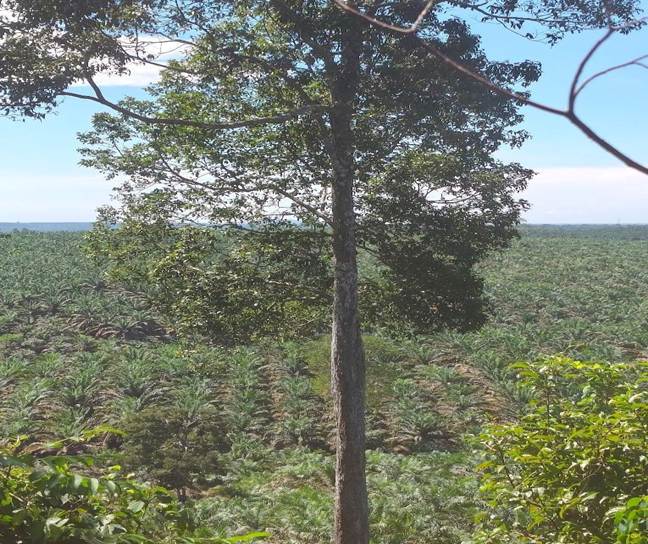
Figure 5. A view of an individual-owned oil palm plantation as seen from within the Rujung Rayo Forest.
Over the past two years, settlement land, farmland/plantations and public facilities have been put forward by the community to the government for release from the KHN through the Land Object of Agrarian Reform (TORA) mechanism, covering approximately 400 ha across some 230 plots. Around 300 KHN boundary markers have been installed at various locations in Kenawan as a first stage, with further stages to follow. In addition, an area of forest covering 359.58 ha in Kenawan has been subject to enforcement action by the Forest Area Enforcement Task Force (Satgas PKH), whose signage has been placed within the plasma plantation belonging to PT Sukses Karya Mandiri.
All of those things mentioned above point to weak community awareness of the need to protect and sustain the forests around them. It is hoped that, through the implementation of the HCS-HCV toolkit carried out together with 4F, community awareness of the importance of forests will grow once again — so that the community comes to see forests not merely as ‘decoration’, but as guardians of the climate, reservoirs of groundwater, safeguards against erosion and flooding, and habitats for biodiversity.